Plans and process
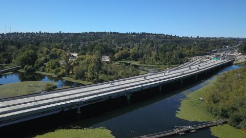
The old SR 520 west approach bridge, built in the early 1960s, served as a vital link between Seattle’s Montlake neighborhood and the SR 520 floating bridge. Built on hollow columns, the old bridge was aging and vulnerable to earthquakes. The new westbound bridge is designed to modern earthquake standards and includes a dedicated HOV/transit lane, providing a safer and more reliable connection.
The West Approach Bridge North Project was the first of the SR 520 Bridge Replacement and HOV Program’s Seattle projects. This project was included in the SR 520 Program’s Final Environmental Impact Statement. We refined the design for the West Approach Bridge North Project as part of various community engagement processes. These processes included local government partners, design professionals and community members. Their input significantly influenced the final design for the project. Examples include adding viewpoints along the SR 520 Trail on the bridge’s north side and aesthetic, fluted support columns. You can read the results of these processes on the SR 520 Program Community Engagement tab.
This project is an important part of the larger, ongoing megaprogram that is reconstructing the SR 520 corridor from I-405 in Bellevue to I-5 in Seattle. Completed phases of the larger SR 520 Bridge Replacement and HOV Program include:
- Floating Bridge and Landings Project, which built the world’s longest floating bridge on Lake Washington between Seattle and the Eastside. This project also built 44 of the bridge’s smaller pontoons in Tacoma.
- Pontoon Construction Project, which built 33 of the new floating bridge’s pontoons, including its massive “longitudinal” pontoons, in Aberdeen, Washington.
- Eastside Transit and HOV Project, which rebuilt the highway’s Eastside segment between I-405 and Lake Washington’s east shore.
The Montlake Project, currently under construction, is completing the second of two parallel west approach bridges over Union Bay. This project also is building a new landscaped lid between Montlake Boulevard and 24th Avenue East, and a bicycle and pedestrian land bridge to the east of the lid.
When the corridor’s reconstruction is fully completed in the late 2020s:
- All of SR 520’s major bridges will be replaced with stronger structures.
- The bus/carpool lanes and a regional bicycle/pedestrian path will extend from Seattle east to Redmond.
- Travelers will have safer on- and off- ramps and improved connections to transit, local streets and the local and regional trail networks.
The new West Approach Bridge North passes over Union Bay and Foster Island before reaching Seattle’s Montlake neighborhood.
Project benefits
SR 520’s 1960s-era west approach bridge, supported by hollow columns, was at risk of failure in a severe earthquake. In addition, the highway’s old, four-lane segment in Seattle is typically at capacity during peak periods. This important new section of the highway connects the floating bridge to Seattle’s Montlake neighborhood. This project provides a number of benefits:
- A safer and seismically stronger westbound bridge designed to withstand a magnitude of earthquake that’s expected to happen only once in 1,000 years.
- Congestion relief and improved regional mobility by extending three westbound lanes, including a dedicated HOV/transit lane, to Montlake.
- Fewer traffic backups thanks to a wide shoulder that allows vehicles to pull over, without blocking traffic, in case of a breakdown.
- Improved multimodal options via an extension of the 14-foot-wide SR 520 Trail across Lake Washington – a new cross-lake connection for the region’s trail network.
- More open and natural park area in the Arboretum with the removal of old ramps that ran through the park. These include an old SR 520 off-ramp and part of the never-completed R.H. Thomson Expressway “Ramps to Nowhere." This is a key part of WSDOT’s commitment to help restore the Arboretum.
The project was funded by a variety of state and federal sources. The final cost of the West Approach Bridge North Project was approximately $264 million.
There currently are no maps or drawings related to this project.
Here are some resources you can use to stay informed about the SR 520 Program:

